LiDAR 3D Scanning Services for AEC, MEP & Industrial Sector

3D Data To Improve Productivity
V3D Technologies specializes in LiDAR 3D scanning services for large, complex, as-built structures that help Architecture, Engineering, and Construction (AEC) professionals accelerate the documentation process of existing conditions while improving accuracy and cutting costs. Using an accurate LiDAR 3D scanner, we will generate 3D point cloud data to help you and your team better evaluate, compare, and rank the environmental and financial impacts of the proposed design in the context of real-world conditions. Our 3D solutions will help you conserve the most valuable commodity – your time.
Critical, yet
Most Accurate Step
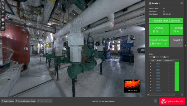
The foremost and critical step is accurate 3D point cloud generation of existing space or structure. We do this accurately use industry-leading laser scanning equipment, technology, and processes. Visual and dimensional information of your space or structure is captured by generating colorized point cloud within millimeter accuracy. Multiple overlapping scans taken from various angles within the same space are then brought into a common reference system where data is merged into a complete model. This process is called alignment or registration. After registration, the complete point cloud model can be published as a ReCap file (RCS/RCP) or other industry-standard formats (E57, XYZ, LGS, PTS, LAS).

Our Process

Define your space/environment to be scanned
Tell us your end goal (Point cloud/BIM/CAD model/2D
drawing/Virtual Tour)

We provide quote based on your requirements

We schedule our visit to scan your space/structure

We provide the deliverables as requested
LiDAR Deliverables
Point Cloud Generation
 Point clouds represent a fundamental aspect of 3D scanning and modeling within various industries, including architecture, engineering, and construction. They are a collection of data points in a 3D coordinate system, each point possessing defined spatial coordinates and sometimes additional information like color or intensity.
Generated using LiDAR 3D scanner, point clouds offer a detailed and accurate depiction of physical objects or environments with-in millimeter accuracy. These data-rich representations allow to capture existing conditions of structures, landscapes, or objects with remarkable precision. Using specialized software, point clouds are processed, analyzed, and converted into tangible 3D models or integrated into Building Information Modeling (BIM) workflows.
Point clouds also facilitate precise measurements, enabling architects and engineers to assess spatial relationships, dimensions, and volumes. Additionally, they support clash detection, aiding in identifying conflicts within designs or during construction phases.
Furthermore, point clouds act as a visual reference for renovation projects, helping in the accurate assessment of as-built conditions, facilitating historical preservation, and enabling the creation of immersive visualizations or virtual reality experiences.
CAD Update for As-Built
 Computer-Aided Design (CAD) models for as-built conditions play a pivotal role in architecture, engineering, and construction (AEC) industries, providing an accurate digital representation of existing structures or environments. As-built CAD models are created by integrating data collected from 3D scanning technologies, such as laser scanning or photogrammetry, into CAD software.
These models depict the precise geometry, dimensions, and features of structures or spaces, reflecting their real-world conditions. They serve as a crucial reference for architects, engineers, and construction professionals during renovation, retrofitting, or maintenance projects. By overlaying the as-built CAD model onto the original design plans, discrepancies or deviations between the intended design and the actual construction can be identified and addressed.
As-built CAD models also streamline the documentation process, serving as a comprehensive record of the structure’s current state. They facilitate efficient decision-making, aiding in design modifications, structural assessments, and facility management tasks. Moreover, these models contribute significantly to Building Information Modeling (BIM) workflows, enriching the collaborative environment and supporting data-driven analyses.
Building Information Modelling (BIM)
 Building Information Modeling (BIM) stands as a revolutionary methodology within the architecture, engineering, and construction (AEC) sector, revolutionizing the management of digital representations for buildings and infrastructure across their entire lifecycle. It offers a sophisticated, model-based approach that surpasses conventional Computer-Aided Design (CAD) methods, incorporating an array of data and fostering collaborative efforts among project stakeholders.
At its essence, BIM facilitates the development of a comprehensive digital model that encompasses both geometric and non-geometric information. This includes intricate details such as spatial relationships, material specifications, costs, schedules, and more. This information-rich model serves as a collaborative platform where architects, engineers, contractors, and other involved parties can collectively contribute and access real-time data.
BIM’s advantages are multifaceted. It elevates design visualization, enabling stakeholders to immerse themselves in a simulated environment, gaining a profound understanding of the project prior to the actual construction phase. It bolsters decision-making by enabling the exploration of diverse design options and simulating real-world performance, aiding in the early detection of potential clashes or conflicts in the design.
2D Floor Plan and Elevation
 2D-floor plans and elevation drawings are fundamental elements in architectural design and construction documentation. Floor plans provide a bird’s-eye view, showcasing the layout, room dimensions, and spatial relationships within a building or space. They offer a clear representation of the flow and functionality of each level.
Elevation drawings, on the other hand, present a vertical view of the building’s exterior, illustrating its facades, heights, and architectural details. These drawings help visualize the building’s appearance, displaying the design elements and proportions, and aiding in understanding how the structure integrates with its surroundings. Both 2D floor plans and elevation drawings serve as essential communication tools for architects, designers, and builders.
Get detailed 2D elevations, floor plans & section views generated using accurate point cloud models or BIM models. We can provide BIM model and detailed 2D drawings in native file format (Revit, AutoCAD) or neutral format (dxf), which will seamlessly integrate within your workflow.
3D CAD Model (Industrial Installations)
 A 3D CAD model for industrial installations is a detailed digital representation of machinery, equipment, and infrastructure within an industrial setting. These models provide a comprehensive visualization of the layout, allowing engineers and planners to assess spatial arrangements, identify potential clashes, and optimize workflow efficiency. They aid in simulating assembly processes, enabling precise planning for equipment positioning and maintenance access. By incorporating accurate dimensions and components, these 3D models streamline design modifications, enhance safety assessments, and facilitate effective communication among stakeholders. Ultimately, they serve as a crucial tool for planning, designing, and maintaining complex industrial installations.
Matterport 3D Walkthrough Virtual Tour
Matterport 3D Walkthrough virtual tour provides an immediate virtual site tour of your space, allowing all stakeholders to monitor project progress accurately and make informed decisions on the spot. Matterport 3D Walkthrough virtual tour will help reduce site visits by capturing all the data the first time and help communicate key milestones quickly and effectively within your team. Further, we will save you considerable time and resources by replacing thousands of photos by capturing all imagery and data and eliminating the need to document, arrange, and label photos. High-resolution Matterport 3D Walkthrough virtual tour taken will help you and your team perform remote inspections, while the embedded point cloud will let you take measurements offsite.